1.24

17014
Penguins on Dassen Island near Cape Town, South Africa
A small island lying 40 miles north of Cape Town and six or eight miles from the mainland known as Dassen Island belongs to the government and is carefully protected on account of its value in guano and egg production.
It is a small island scarcely more than a mile in length and a half a mile in width and inhabited only by the lighthouse keeper and myriads of penguins. On this small islet area there are estimated to be 360,000 of these sea-birds. Their eggs supply the Cape Town market and large quantities are now shipped to the London market. Upwards of a million eggs are annually obtained from this small island. The birds are flightless and being well protected have become so fearless of man that one can walk amongst their legions and over their burrows without giving them much alarm. Their eggs are laid and their young reared in those shallow burrows to be seen in the picture. They live altogether on fish caught in the sea and it is very amusing to see the parent birds waddling homeward with a good-sized fish in their beaks, or standing at the door of their underground domiciles breaking up and delivering bits of fish to the fuzzy penguinettes.
The noise or call of one of these birds sounds like that of the donkey. The writer has passed a night in the lighthouse on this island, and with him it remains a mystery, how the lighthouse keeper and his family ever succeed in getting a wink of sleep with the unceasing noise as of 360,000 donkeys about their dormitory during every minute of the night.
Copyright by The Keystone View Company
18.60

*2579
Great War Relief of Karnak Temple, Thebes, Egypt
“We are standing outside of the great hypostyle of Karnak, looking southward against the outside of the north wall. Behind this wall is the vast forest of columns which we have already viewed. In three rows, one above the other, Sethos I, whom we saw in the flesh at Cairo, the father of Ramses II, has here depicted the victories which he won in the first years of his reign in the middle of the fourteenth century B.C…. In the lowest row, we see the Pharaoh with drawn bow standing erect in his chariot as he charges the fleeting Hittites (in Syria). In the middle row Sethos is doing battle with the Libyans, who have crossed the northwestern border and invaded the Delta. On the right we see him with the reigns of his plumed war-horses tied tightly about his waist as he urges them in wild career full into the ranks of the enemy. He has exhausted his arrows and holds his now useless bow in his left hand, while, in his uplifted right, he grasps the heavy bronze sword, with which he is beating down the Libyan chief, who has dared to face him. The Libyan may be recognized by the two feather plumes which he wears on his head. On the left in the same row is another incident in the battle, where Sethos, now dismounted from his chariot, raises on high the javelin with which he is about to transfix the Libyan chief, whom he hurls back helpless before him. This is one of the most spirited compositions in Egyptian art.”
(From “Egypt Through the Stereoscope,” by James H. Breasted, Ph.D.)
19.16

W28387
Strange Stonehenge on the Salisbury Plain
Salisbury Plain in Wiltshire is one of the prehistoric centers of England. On these green chalk downs stands a mysterious monument, eloquent of a life throbbing on this plain when London was but a marsh. Whether Stonehenge is the ruins of a Druid fane or a sun temple is not known. It may even have been a mighty sepulchre for fallen heroes.
The name is from the Saxon and means hanging stones. It is very probable that it was built at the end of the stone age or early in the bronze age. When complete, before the ages set their stamp upon it, the monument must have been surrounded by a low circular earthwork about 300 feet in diameter. Within this were two concentric circles of standing stones. Within these circles were two other groups of stone, arranged in horseshoe form, one within the other. Within the inner horseshoe, opposite the open end, was the fifteen-foot altar stone. Where the axis running east from the altar stone through the opening of the horseshoe cuts the earthen circle was a recumbent sacrificial stone, and still farther along the northeast axis was the solitary sun stone. Over this sun stone on “Midsummer Day” the rays of the rising sun strike to the heart of the temple, even as they did in the by-gone ages when throngs of sun-worshippers were wont to gather here to hail its coming. Following an ancient tradition, which the people cannot explain, it has long been a custom of the neighborhood to go out to Stonehenge on the night of the Midsummer Eve and watch for the sun to rise across the altar stone.
Copyright by Keystone View Company
20.2
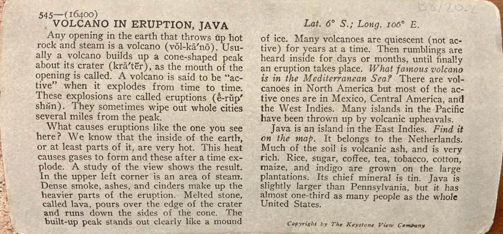
545—(16400)
Volcano in Eruption, Java
Lat. 6° S.; Long. 106° E.
Any opening in the earth that throws up hot rock and steam is a volcano (vŏl-kā’nō). Usually a volcano builds up a cone-shaped peak about its crater (krā’tẽr), as the mouth of the opening is called. A volcano is said to be “active” when it explodes from time to time. These explosions are called eruptions (ē-rŭp’shŭn). They sometimes wipe out whole cities several miles from the peak.
What causes eruptions like the one you see here? We know that the inside of the earth, or at least parts of it, are very hot. This heat causes gases to form and these after a time explode. A study of the view shows the result. In the upper left corner is an area of steam. Dense smoke, ashes, and cinders make up the heavier parts of the eruption. Melted stone, called lava, pours over the edge of the crater and runs down the sides of the cone. The built-up peak stands out clearly like a mount of ice. Many volcanoes are quiescent (not active) for years at a time. Then rumblings are heard inside for days or months, until finally an eruption takes place. What famous volcano is in the Mediterranean Sea? There are volcanoes in North America but most of the active ones are in Mexico, Central America, and the West Indies. Many Islands in the Pacific have been thrown up by volcanic upheavals.
Java is an island in the East Indies. Find it on the map. It belongs to the Netherlands. Much of the soil is volcanic ash, and is very rich. Rice, sugar, coffee, tea, tobacco, cotton, maize, and indigo are grown on the large plantations. Its chief mineral is tin. Java is slightly larger than Pennsylvania, but is has almost one-third as many people as the whole United States.
Copyright by The Keystone View Company
20.7
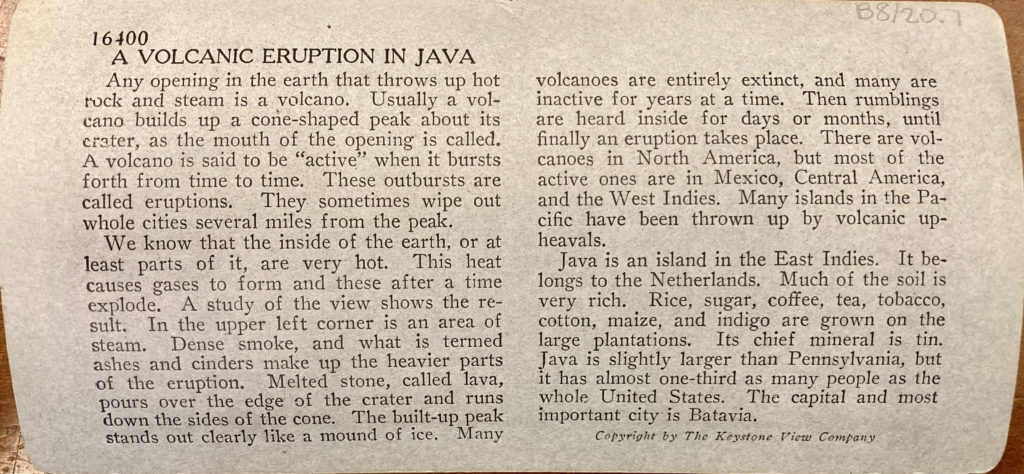
16400
A Volcanic Eruption in Java
Any opening in the earth that throws up hot rock and steam is a volcano. Usually a volcano builds up a cone-shaped peak about its crater, as the mouth of the opening is called. A volcano is said to be “active” when it explodes from time to time. These outbursts are called eruptions. They sometimes wipe out whole cities several miles from the peak.
We know that the inside of the earth, or at least parts of it, are very hot. This heat causes gases to form and these after a time explode. A study of the view shows the result. In the upper left corner is an area of steam. Dense smoke, ashes, and cinders make up the heavier parts of the eruption. Melted stone, called lava, pours over the edge of the crater and runs down the sides of the cone. The built-up peak stands out clearly like a mount of ice. Many volcanoes are entirely extinct, and many are inactive for years at a time. Then rumblings are heard inside for days or months, until finally an eruption takes place. There are volcanoes in North America, but most of the active ones are in Mexico, Central America, and the West Indies. Many Islands in the Pacific have been thrown up by volcanic upheavals.
Java is an island in the East Indies. Find it on the map. It belongs to the Netherlands. Much of the soil is volcanic ash, and is very rich. Rice, sugar, coffee, tea, tobacco, cotton, maize, and indigo are grown on the large plantations. Its chief mineral is tin. Java is slightly larger than Pennsylvania, but is has almost one-third as many people as the whole United States. The capital and most important city is Batavia.
Copyright by The Keystone View Company
29.183
You are looking nearly west across this square. The famous Arno river is half a mile away at your left. This group of buildings right here is one of the most celebrated in all Europe, partly for the beauty of the structure and partly for the fascinating eccentricity of the taller one.
“The marble tower at which you are looking leans thirteen feet from the perpendicular. Even as you gaze on it, it seems in the act of falling. Standing upon the top and looking down, you feel that you are falling with the tower and you instinctively grasp the railing in front of you in a desperate effort to save yourself. The interior is hollow and one can look down into it as into a gigantic tube. The structure is 180 feet high and is crowned by a belfry which contains seven bells. (You can see them from here.) The heaviest weighs six tons and hangs on the side opposite the overhanging wall. There has been controversy as to the cause of this strange phenomenon which has existed for 550 years. Some maintain that it was built in this way as an architectural novelty, but the best explanation is that the ground settled in the course of its construction and the upper stories were added in a curved line, the walls on the leaning side being strengthened to bear the strain.
The grand old cathedral, one of the finest in the world, was constructed after a great naval victory of the Pisans in the eleventh century. In the dim light of its vast and splendid interior I looked upon the altar-lamp, still hanging there, whose oscillations suggested to Galileo the idea of the pendulum. Our position here gives us a rear view of the building, but from every point of observation it is imposing. It is actually 312 feet long and 107 feet in breadth, and, like the bell tower, is constructed entirely of marble. Over the roof we have a glimpse of the top of the Baptistery.”
(Extracts from Italy through the Stereoscope, with special “keyed” maps locating one hundred standpoints and identifying all the landmarks; published by Underwood & Underwood.)
—
The Famous Leaning Tower and Cathedral, Pisa, Italy.
La fameuse Tour inclinée et la Cathédrale, de Pise, Italie.
Der berühmte schiefe Turm und die Kathedrale, von[?] Pisa in Italien.
La famosa Torre inclinada y la Catedral, de Pisa, Italia.
[the following two lines are too worn off to transcribe, but presumably, they translate the preceding lines in Swedish and Russian]
37.8
Boehl & Koenig’s Views of Shaw’s Missouri Botanical Garden, Tower Grove, Lafayette, Benton and Forest Parks, Fair Grounds, Etc., 707 N. 4th Street, St. Louis.
Shaw’s Garden.
1. Main Entrance, outside view
2. Mausoleum
3. Main entrance, inside view
4. Front of Parterre
5. Rose Patch and Summer-house
6. Museum
7. Residence of Mr. Henry Shaw
8. Pavillion
9. Parterre and Palm-house
10. Pavillion from East
11. Parterre & plant houses
12. Green House in the distance.
13. Palm-House from Pavillion
14. [underlined] Central View from Palm-House
15. North End, showing new Palm-House
16. General View from Palm-house
17. Group of Bible Plants
18. Gorgon Plants
19. Tropical Fruit Plants
20. Interior of large Plant-house
21. Interior of Tropical house, No. 2
22. Interior of small Plant-house
23. Int. succulent house, northern view
24. Do southern view
25. Int. of Palm-house, western wing
26. Do eastern “
27. Do west entrance
28. Do east “
29. Temple of Victory
30. Vine Arbor, Fructicetum
31. Summer-house in Fructicetum
32. From Residence, northern view
33. From Residence Tower Grove Park in the distance
34. Henry Shaw, Esq.
35. Ent. to private garden
36. Tower view from “
Tower Grove Park.
155. Plant House
156. Music Pavillion
157. Interior of Plant-house
158. Group of Bananas
159. Main entrance outside
160. Fountain, etc.
161. Shakespeare statue
162. Summer-house s. w. of entrance
163. Humboldt statue
164. Fr. centre looking east
165. Summer-house s. ent.
166. From Sup’t res. east
167. North Gate
168. Columbus Statue
169. West Gate inside
170. Fr. Sup’t residence w.
Fair Grounds.
171. Bear Pits
172. Aviary
173. General View north
174. Carnivora House
175. Secretary’s office
176. Fine Art Hall
177. Fr. Amphith’re east
178. Summer-h. Lake &c.
179. Main entrance east side
180. Monkey House
181. Amphitheatre
182. Sup’t residence
183. Pagoda in centre of Amphitheatre
184. Mechanical Dep’t
185. Grotto in Flora Hall
186. Birds of Prey house
Lafayette Park.
187. Bridge from east side
188. From entrance s. w.
189. Bridge west side
190. Summer-house above Grotto
191. Musician Stand
192. View from N. W.
193. Police stations front
194. Washington statue
195. Benton statue
196. Sup’t cottage
197. Boat-riding on lake
198. Waiting for the boat
199. Lake and fountain east
200. Summer-house near main entrance
201. Lake and Cascade w. side of Park
202. From Police Station west
Benton Park.
244. From Bridge west
245. Island in Long Lake
246. Rustic Summer-house over Tunnel
247. Pavillion, from south
248. Rose Patch, etc.
249. From Pavillion, west
250. Round Pond and Fountain, etc.
251. Lake and Bridge south
252. Tunnel from East
Sundry Views.
253. Highest Point of Iron Fountain
254. Granite quarry
255. Shut in at Pilot Knob
256. River des Pere at Laclede Station
257. Gen. Grant’s Farm on Gravois Road
258. Granite Bolders
259. Elephant and Bolders
260. Elephant from South
261. Fire Engine
262. do ready to start
263. Old Chouteau Mansion Park Avenue
264. U. S. Snag Boat Wagner
265. Jupiter Iron Works
266. Water Tower (new)
267. Water Tower.
—
For Public Buildings Bridges, Street Views, &c. see other Catalogue.
39.56

No. 1287. Castle Geyser and Diana’s Pool, Yellowstone National Park.
Castle Geyser, which received its very appropriate name from the Washburn party in 1870, is a very whimsical geyser. Its cone resembles a diminutive castle ruin, and its eruption, half steam and half water, ordinarily does not reach above 75 feet, but occasionally it displays great style, rising to the magnificent height of 200 feet, the steam floating still a few hundred feet higher and forming a wondrous spectacle. The periods of the geyser are irregular. Sometimes it spouts after a rest of eight hours, sometimes it rests up to thirty hours and varies constantly. Nor is the length of the period of rest any sign of the height to which the following eruption will throw the water.
General Washburn’s diary contained what is undoubtedly the first sketch or map of Yellowstone Lake ever made. It was drawn from observations of his own from a high point on the east side of the lake climbed by Washburn and Hauser on September 5th, supplemented by reports by Langford and Hauser who ascended a mountain on the west side overlooking the lake, on September 10th. The map shows the three islands.
44.157

32400
1928 first model A’s
“The Great White Way,” New York
The blazing illumination occasioned by millions of electric lights, turning the hours of darkness to the brightness of noon, is an event of nightly occurrence in the theatrical district of New York and one which adds immeasurably to the glamour of this greatest amusement center of the world. New York City boasts about 80 standard theaters, an equal number of vaudeville houses and music halls and more than 1,700 motion picture houses, possessing, between them, a seating capacity of over 1,000,000. Of these places, the best and the largest are on or close to Broadway between 38th and 62nd Streets, and it is in this section of Broadway which is popularly known as “The Great White Way.”
We are standing near the intersection of 54th Street and 7th Avenue, looking down the latter into Broadway and southward along an important stretch of “The Great White Way.” Here most of the successful plays and pictures of the United States have their first presentations and achieve their reputations. Some idea of the average size of these theaters may be gained from the statement of the capacity of a few whose electric signs are visible from this point. The “Roxy,” whose name glows against the night sky, can seat an audience of 5,920 persons; “Warner’s” will accommodate 1,286; the “Capitol,” 4,624; the “Rivoli,” 2,122, and the “Strand,” 2,989. These five theaters alone, which are but a few among many, would therefore seat the entire population city of 17,000 people. The largest auditorium in New York is the new Madison Square Garden, which holds 23,000 people. The Metropolitan Opera House, the chief center of grand opera in America, accommodates 3,305 people.
Copyright by The Keystone View Company
44.177

33—(18203)
“The House Beautiful”—Brooklyn, N. Y.
Lat. 41° N.; Long. 74° W.
033-UH-91
Making a home attractive is one of the finest of arts. Nothing so makes life worth while and full of richness as a well appointed place to live. We are too often satisfied with cheap prints in place of pictures, gaudy wallpaper, any kind of rugs, and furniture of all sorts.
When we see an interior nicely fitted as this one, we say, “What fine taste!” But taste is not altogether a natural gift. Like other virtues, it must be cultivated. To teach girls how to furnish their homes properly is the purpose of Domestic Art. Everywhere schools are coming to have courses in this art, and many large special schools, such as the Pratt Institute in Brooklyn, enjoy a national reputation.
In furnishing your rooms at home, or in decorating a school room, simplicity is the first law. Most homes are “cluttered up” with a bit of everything. A few good pieces cost no more and are in much better taste than many cheap imitations.
Why are these two rooms attractive? First, because nothing is overdone. The furnishings are not in each other’s way. The attractiveness of the table is not hidden by a cloth. But its top is protected by the doilies and a pleasing contrast is also secured. The chairs are simple in line. The flower-pot matches its surroundings. The dishes, too, appear to belong in that particular dining-room and on that very table. This leads to the second reason for the attractiveness of this room—the arrangement.
You can think of the effect of this beauty being lost by a bad distribution of the furniture. Observe the placement of each piece. Each is put where it is because it was selected to fit into the scheme of these rooms. The basis of the choice of furnishings is the rooms themselves.
Copyright by the Keystone View Company.
50.1
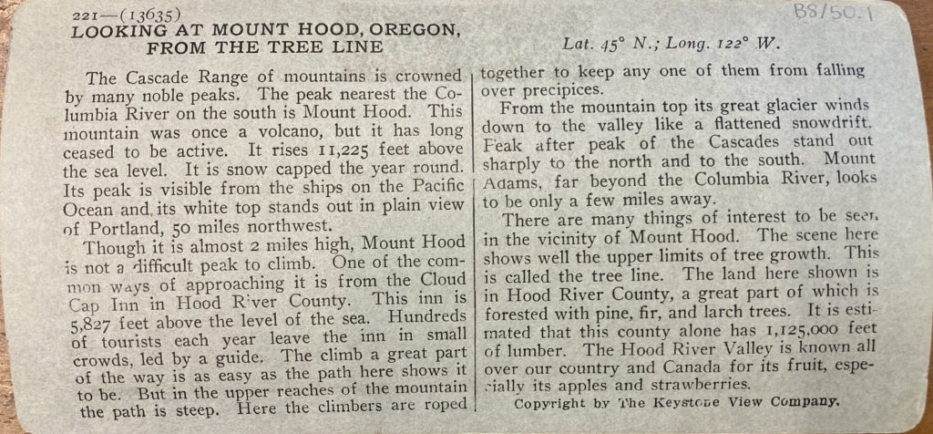
221—(13635)
Looking at Mount Hood, Oregon, from the Tree Line
Lat. 45° N.; Long. 122° W.
The Cascade Range of mountains is crowned by many noble peaks. The peak nearest the Columbia River on the south is Mount Hood. This mountain was once a volcano, but it has long ceased to be active. It rises 11,225 feet above the sea level. It is snow capped the year round. Its peak is visible from the ships on the Pacific Ocean and its white top stands out in plain view of Portland, 50 miles northwest.
Though it is almost 2 miles high, Mount Hood is not a difficult peak to climb. One of the common ways of approaching it is from the Cloud Cap Inn in Hood River County. This inn is 5,827 feet above the level of the sea. Hundreds of tourists each year leave the inn in small crowds, led by a guide. The climb a great part of the way is as easy as the path here shows it to be. But in the upper reaches of the mountain the path is steep. Here the climbers are roped together to keep any one of them from falling over precipices.
From the mountain top its great glacier winds down to the valley like a flattened snowdrift. Peak after peak of the Cascades stand out sharply to the north and to the south. Mount Adams, far beyond the Columbia River, looks to be only a few miles away.
There are many things of interest to be seen, in the vicinity of Mount Hood. The scene here shows well the upper limits of tree growth. This is called the tree line. The land here shown is in Hood River County, a great part of which is forested with pine, fir, and larch trees. It is estimated that this county alone has 1,125,000 feet of lumber. The Hood River Valley is known all over our country and Canada for its fruit, especially its apples and strawberries.
Copyright by the Keystone View Company.
54.1
[a printed illustration of two horses on either side of an emblem with an eagle on it, beneath them a ribbon reading, “Virtue Liberty Independence”]
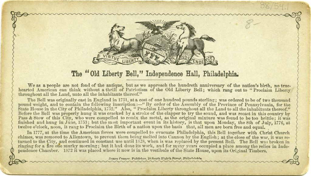
The “Old Liberty Bell,” Independence Hall, Philadelphia.
We as a people are not fond of the antique, but as we approach the hundreth anniversary of the nation’s birth, no true-hearted American can think without a thrill of Patriotism of the Old Liberty Bell; which rang out to “Proclaim Liberty throughout all the Land, unto all the inhabitants thereof.”
The Bell was originally cast in England in 1751, at a cost of one hundred pounds sterling; was ordered to be of two thousand pound weight, and to contain the following inscription:—”By order of the Assembly of the Province of Pennsylvania, for the State House in the City of Philadelphia, 1752.” Also, “Proclaim Liberty throughout all the Land to all the inhabitants thereof.” Before the Bell was properly hung it was cracked by a stroke of the clapper to try the sound, and was recast in this country by Pass & Stow of this City, who were compelled to remix the metal, as the original mixture was found to be too brittle; it was finished and hung in June, 1753; but the most important event in its history, is that upon Monday, the 8th of July, 1776, at twelve o’clock, noon, it rang to Proclaim the Birth of a nation upon the basis that, all men are born free and equal.
In 1777, at the time the American forces were compelled to evacuate Philadelphia, this Bell together with Christ Church chimes, was removed to Allentown, to prevent them being melted into Cannon by the English; at the close of the war, it was returned to the City, and continued in constant use until 1828, when is was replaced by the present Bell. The Bell was broken in ringing for a fire one murky morning; but it had done its work, and for many years occupied a place among the relics in Independence Chamber. 1872 it was placed where it now is in the vestibule of the State House, upon its Original Timbers.
James Cremer, Publisher. 18 South Eighth Street, Philadelphia.
59.40

As we stand here on the heathery bank of Loch Katrine, 400 feet above sea level, we catch a glimpse of one of the loveliest features the Trossachs afford. This lake is not very large—scarcely ten miles long, in fact—but, for its size, it is very deep—not less than 500 feet in depth in some places. It is the source of Glasgow’s water supply, which is conveyed by gravitation through an aqueduct, and for purity and wholesomeness its water is unexcelled. Placid and clear, its water reflects as from a mirror the surrounding scenery. (Invert the stereograph and you have a double view hardly less perfect when reversed, so tranquil is its surface.) This beautiful lake is the upper reservoir of the River Teith, which flows from here through the picturesque gorge of the Trossachs, forming a junction near Callander with the overflow from Loch Lubnaig and joining the Forth northwest of Stirling. On its north side Ben A’n rises to an altitude of 1800 feet, and on the south, Ben Venue towers 2863 feet aloft, pouring numerous streamlets into the loch. That steamer would take us past Ellen’s Isle, the sylvan retreat of the Lady of the Lake, the heroine of Sir Walter Scott’s romantic poem. It was on one of the hills above this lake that Sir Walter made his hero meet the highland rebel and his men:—
“These are Clan Alpine’s warriors true,
And, Saxon, I am Roderick Dhu!”
This islet seems to float in beauty on the water—a dream within a dream, far, “far from the madding crowd,” though we are actually only about sixty miles from Edinburgh.
Read:—
Sir Walter Scott: The Lady of the Lake.
—
Loch Katrine, Scotland.
Le Lac Katrine, Ecosse.
Loch Katrine, Schottland.
El Lago Katrine, Escocia.
Loch Katrine, Skottland.
Озерo Катрин’ь в’ь Шотландік.
59.45
V12748
| Series | 400 | 200 | 100 |
| Position | 73 | 40 | 26 |
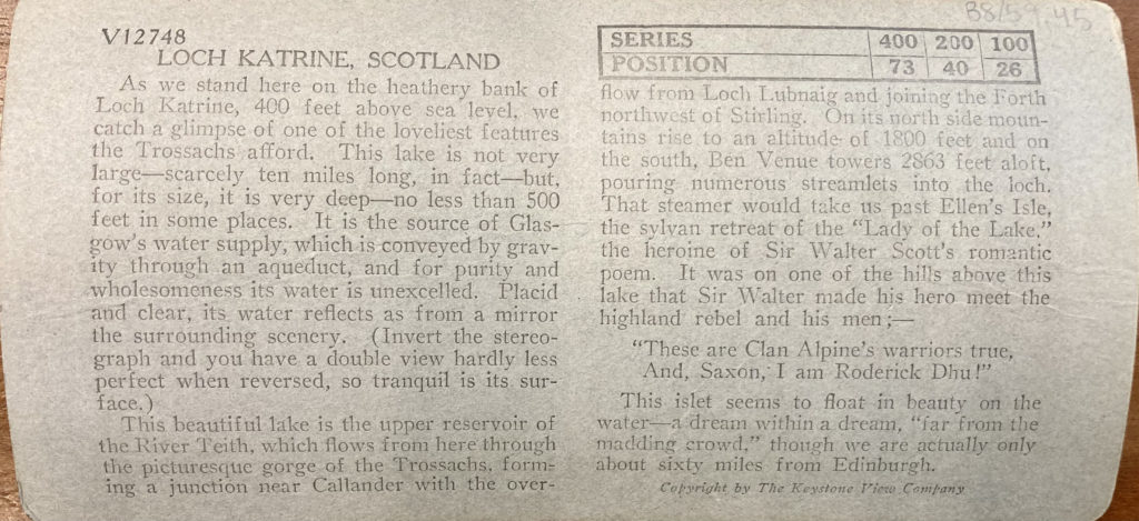
Loch Katrine, Scotland
As we stand here on the heathery bank of Loch Katrine, 400 feet above sea level, we catch a glimpse of one of the loveliest features the Trossachs afford. This lake is not very large—scarcely ten miles long, in fact—but, for its size, it is very deep—no less than 500 feet in some places. It is the source of Glasgow’s water supply, which is conveyed by gravity through an aqueduct, and for purity and wholesomeness its water is unexcelled. Placid and clear, its water reflects as from a mirror the surrounding scenery. (Invert the stereograph and you have a double view hardly less perfect when reversed, so tranquil is its surface.)
This beautiful lake is the upper reservoir of the River Teith, which flows from here through the picturesque gorge of the Trossachs, forming a junction near Callander with the overflow from Loch Lunbaig and joining the Forth northwest of Stirling. On its north side mountains rise to an altitude of 1800 feet and on the south, Ben Venue towers 2863 feet aloft, pouring numerous streamlets into the loch. That steamer would take us past Ellen’s Isle, the sylvan retreat of the “Lady of the Lake,” the heroine of Sir Walter Scott’s romantic poem. It was on one of the hills above this lake that Sir Walter made his hero meet the highland rebel and his men;—
“These are Clan Alpine’s warriors true,
And, Saxon, I am Roderick Dhu!”
This islet seems to float in beauty on the water—a dream within a dream, “far from the madding crowd,” though we are actually only about sixty miles from Edinburgh.
Copyright by The Keystone View Company
63.18

32187
In the Heart of Atlanta, Ga.
In a state where over 8,000,000 peach trees blossom each spring, it seems most fitting that the main street of its capital should be named Peachtree. But this name has nothing to do with peach trees. It owes its origin to the pitch tree which marked the ridge where the Creek and Cherokee Indians traded. Peachtree Street runs along that same ridge so today Atlanta still trades where the Indians traded. Beginning as a railhead it took the name of Terminus, then changed to Marthasville, and in 1847 to Atlanta.
Burned by the North at the time of General Sherman’s famous “march to the sea,” the city quickly recovered following the war of Secession, and as we look up Peachtree Street toward the Five Points, we can appreciate how the business section of Atlanta today presents an amazing contrast to the charred mass that was left standing in 1864. In the place of the small stores of a town once possessing but one railway and one newspaper, there now stands this solid mass of skyscrapers rising before you. Today Atlanta has fifteen railway lines and six daily newspapers. It is said that one hundred and forty-eight passenger trains arrive in the city daily. It is this great network of railways that has made the city the gateway of the Gulf States and one of the greatest distributing centers of the South.
Atlanta also has a large number of manufacturing plants making no less than one thousand and five hundred commodities and its telegraph business is said to be the third largest in the world. Here in the New York of the South has been developed one of the richest business sections in America.
Copyright by Keystone View Company
68.6

34174
The Empire State Building from the Air
From the ground it is difficult to judge the comparative height of these tall buildings because they are all so far above us. But, as from a great elevation above the buildings it is fascinating to note how they stand out. Towering above all others, the Empire State Building, the world’s tallest skyscraper, rises immediately below us.
It is New York City’s most dramatic building and will probably set the limit of height to which tall buildings will aspire. It is 1,250 feet tall and has 102 stories. It rises twenty-five stories higher than New York’s next tallest, the Chrysler Building. The sun rises a half hour earlier and sets that much later to those who may be atop this building. So tall is the Empire State it has been necessary to equip it with special mail chutes which automatically retard the speed of letters at the 65th and 27th floors to prevent them from becoming scorched by the friction that would result from a continuous fall.
The Empire State Building stands on the west side of Fifth Avenue, extending from 33rd Street to 34th Street. From the sign on the roof, you can observe that one of New York’s famous department stories stands across the street. The old Waldorf-Astoria Hotel occupied this site of the Empire State Building and so solid was its construction that it cost $900,000.00 to wreck it.
Well named is the Empire State Building. It bears the popular name for the state of New York which was inferentially given the state back in the time of Washington when he said “your state, at present the seat of Empire.”
68.35

29600
The Eiffel Tower, Paris, France.
No Frenchman and no visitor to France of the present day could imagine a perspective of Paris in which the most conspicuous object would not be the Eiffel Tower. As one writer has said, in describing a view of the city from one of the distant hills which surround it: “Through the pearly haze of the afternoon sunshine, … at one extremity of the splendid panorama, like the pillar of cloud set by Jehovah before the face of Israel, rushes skyward the shaft of the Eiffel Tower, about whose pinnacle play the invisible lightnings that syllable men’s thoughts across the seven seas.” The last words refer to the fact that the tower houses one of the most powerful wireless telegraph stations in existence, which during the World War played a prominent part in the radio communications of the Allies. Ever since it was built for the Paris exposition of 1889, the Eiffel Tower has dominated the skyline of the city, and in the huge elevators which travel to its top, millions of visitors have ascended it to enjoy the vast outlook visible from its apex.
The tower was built by the French Engineer, Alexandre Gustave Eiffel. It rises 300 meters (984 feet) above the ground. Its base consists of four great uprights of iron lattice work, which, about half-way to the top, unite in a single shaft, so large that the pavilion on the third platform, 900 feet above the street, will hold 800 people. Only two other buildings in all the world exceed it in height, both New York skyscrapers. One is the Chrysler Building, completed in 1930, which with its steeple rises 1,046 feet from the ground; the other, the Empire State Building (1931), 1,248 feet high.
Copyright by The Keystone View Company
68.82
16648
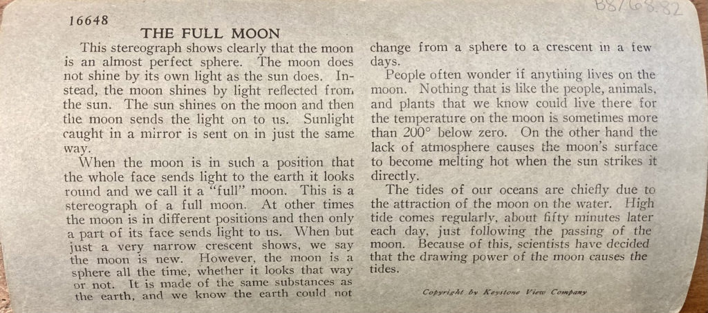
The Full Moon
This stereograph shows clearly that the moon is an almost perfect sphere. The moon does not shine by its own light as the sun does. Instead, the moon shines by light reflected from the sun. The sun shines on the moon and then the moon sends the light on to us. Sunlight caught in a mirror is sent in just the same way.
When the moon is in such a position that the whole face sends light to the earth it looks round and we call it a “full” moon. This is a stereograph of a full moon. At other times the moon is in different positions and then only a part of its face sends light to us. When but just a very narrow crescent shows, we say the moon is new. However, the moon is a sphere all the time, whether it looks that way or not. It is made of the same substances as the earth, and we know the earth could not change from a sphere to a crescent in a few days.
People often wonder if anything lives on the moon. Nothing that is like the people, animals, and plants that we know could live there for the temperature on the moon is sometimes more than 200° below zero. On the other hand the lack of atmosphere causes the moon’s surface to become melting hot when the sun strikes it directly.
The tides of our oceans are chiefly due to the attraction of the moon on the water. High tide comes regularly, about fifty minutes later each day, just following the passing of the moon. Because of this, scientists have decided that the drawing power of the moon causes the tides.
Copyright by Keystone View Company
75.52

We stand looking southwestward toward the heart of Africa, with Cairo almost behind us and Memphis on our left. Before us looms the second pyramid; this is probably not the best point of view from which to be impressed with its size, and yet, when you remember that yonder cap of casing masonry which still crowns it extends for 150 feet down its sides, this may serve as a scale by which to measure the rest. Lifted as we are upon the shoulders of the Great Pyramid, we are taking an unfair advantage in thus looking down upon its slightly smaller neighbor. But how splendidly it rises against that background of billowy desert which stretches away southward.
Farther east (left) you observe three low, sand covered walls, two extending eastward and one at right angles to these. The farther of the two parallel walls is the upper end of a causeway leading from the plain to the desert plateau, up which the building material was transported, and by means of which, after the king’s death, access was gained to the temple of the pyramid, where his mortuary ritual was regularly carried on by an endowed priesthood. The ruins down at the left below our feet (seen over that standing native’s head) are the remains of the temple of the second pyramid…. There, in that desolate, sand-covered ruin, once a splendid sanctuary, an endowed priesthood carried on the ritual and worship of the dead Khafre who lay in the pyramid; and there, from the foundations established by the king for the purpose, he daily received offerings of food and drink.”
(From “Egypt Through the Stereoscope, by James H. Breasted, Ph.D., with twenty patent maps and plans. Copyright, by Underwood & Underwood.)
—
The Second Pyramid, showing part of the original covering. Egypt.
La Seconde Pyramide, montrant une partie de la couverture primitive, Egypte.
La Segunda Pirámide, mostrando parte de la cubierta primitiva, Egipto.
Die zweite Pyramide mit ihrer theilweisen, ursprünglichen Deckung, Egypten.
Andra pyramiden med en del af dess ursprungliga hölje Egypten.
Вторая пирамида, показывающая часть древнихъ украш ній, Египетъ.
76.15
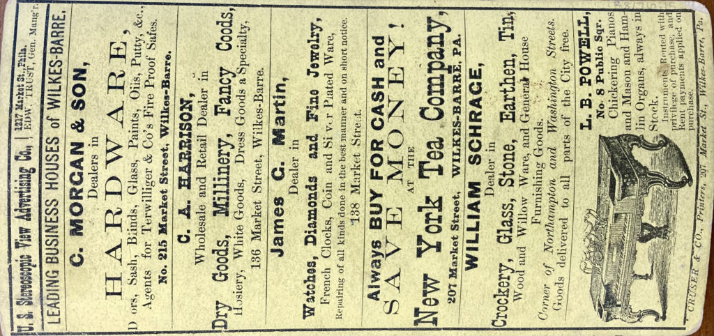
U. S. Stereoscopic View Advertising Co., 1217 Market St., Phila. Edw. Trust, Gen. Mang’r.
—
Leading Business Houses of Wilkes-Barre.
C. Morgan & Son, Dealers in Hardware, Doors, Sash, Blinds, Glass, Paints, Oils, Putty, &c., Agents for Terwilliger & Co’s Fire Proof Safes. No 215 Market Street, Wilkes-Barre.
C. A. Harrison, Wholesale and Retail Dealer in Dry Goods, Millinery, Fancy Coods, Hosiery, White Goods, Dress Goods a Specialty, 136 Market Street, Wilkes-Barre.
James G. Martin, Dealer in Watches, Diamonds and Fine Jewelry, French Clocks, Coin and Silver Plated Ware, Repairing of all kinds done in the best manner and on short notice. 138 Market Street.
Always Buy for Cash and Save Money! at the New York Tear Company, 207 Market Street, Wilkes-Barre, PA.
William Schrage, Dealer in Crockery, Glass, Stone, Earthen, Tin, Wood and Willow Ware, and General House Furnishing Goods. Corner of Northampton and Washington Streets. Goods delivered to all parts of the City free.
[illustration of a piano] L. B. Powell, No. 8 Public Sqr. Chickering Pianos and Mason and Hamlin Organs, always in Stock. Instruments Rented with privilege of purchase, and Rent payments applied on purchase.
Cruser & Co., Printers, 207 Market St., Wilkes-Barre, Pa.
76.77
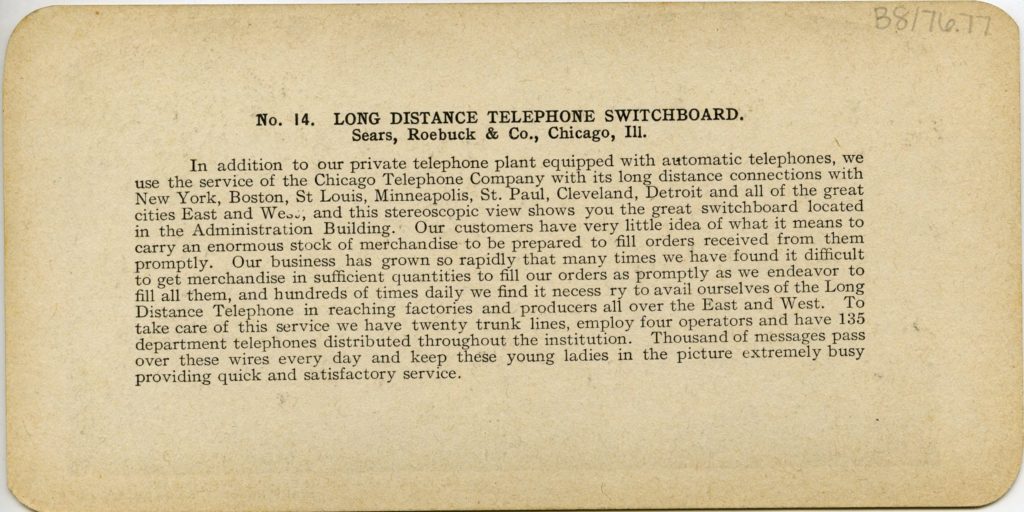
No. 14. Long Distance Telephone Switchboard.
Sears, Roebuck & Co., Chicago, Ill.
In addition to our private telephone plant equipped with automatic telephones, we use the service of the Chicago Telephone Company with its long distance connections with New York, Boston, St Louis, Minneapolis, St. Paul, Cleveland, Detroit and all of the great cities East and West, and this stereoscopic view shows you the great switchboard located in the Administration Building. Our customers have very little idea of what it means to carry an enormous stock of merchandise to be prepared to fill orders received from them promptly. Our business has grown so rapidly that many times we have found it difficult to get merchandise in sufficient quantities to fill our orders as promptly as we endeavor to fill all them, and hundreds of times daily we find it necessary to avail ourselves of the Long Distance Telephone in reaching factories and producers all over the East and West. To take care of this service we have twenty trunk lines, employ four operators and have 135 department telephones distributed throughout the institution. Thousand of messages pass over these wires every day and keep these young ladies in the picture extremely busy providing quick and satisfactory service.
93.14
600—(16645)
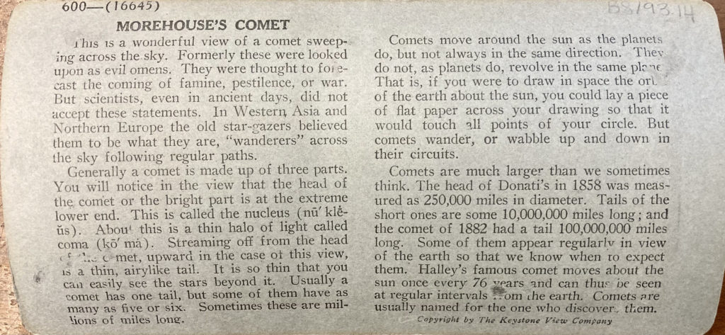
Morehouse’s Comet
This is a wonderful view of a comet sweeping across the sky. Formerly these were looked upon as evil omens. They were thought to forecast the coming of famine, pestilence, or war. But scientists, even in ancient days, did not accept these statements. In Western Asia and Northern Europe the old star-gazers believed them to be what they are, “wanderers” across the sky following regular paths.
Generally a comet is made up of three parts. You will notice in the view that the head of the comet or the bright part is at the extreme lower end. This is called the nucleaus (nū’klē-ŭs). About this is a thin halo of light called coma (kō’mȧ). Streaming off from the head of the comet, upward in the case of this view, is a thin, airylike tail. It is so thin that you can easily see the stars beyond it. Usually a comet has one tail, but some of them have as many as five or six. Sometimes these are millions of miles long.
Comets move around the sun as the planets do, but not always in the same direction. They do not, as planets do, revolve in the same plane. That is if you were to draw in space the orbit of the earth about the sun, you could lay a piece of flat paper across your drawing so that it would touch all points of your circle. But comets wander, or wabble up and down in their circuits.
Comets are much larger than we sometimes think. The head of Donati’s in 1858 was measured as 250,000 miles in diameter. Tails of the short ones are some 10,000,000 miles long; and the comet of 1882 had a tail 100,000,000 miles long. Some of them appear regularly in view of the earth so that we know when to expect them. Halley’s famous comet moves about the sun once every 76 years and can thus be seen at regular intervals from the earth. Comets are usually named for the one who discovered them.
Copyright by The Keystone View Company
96.7
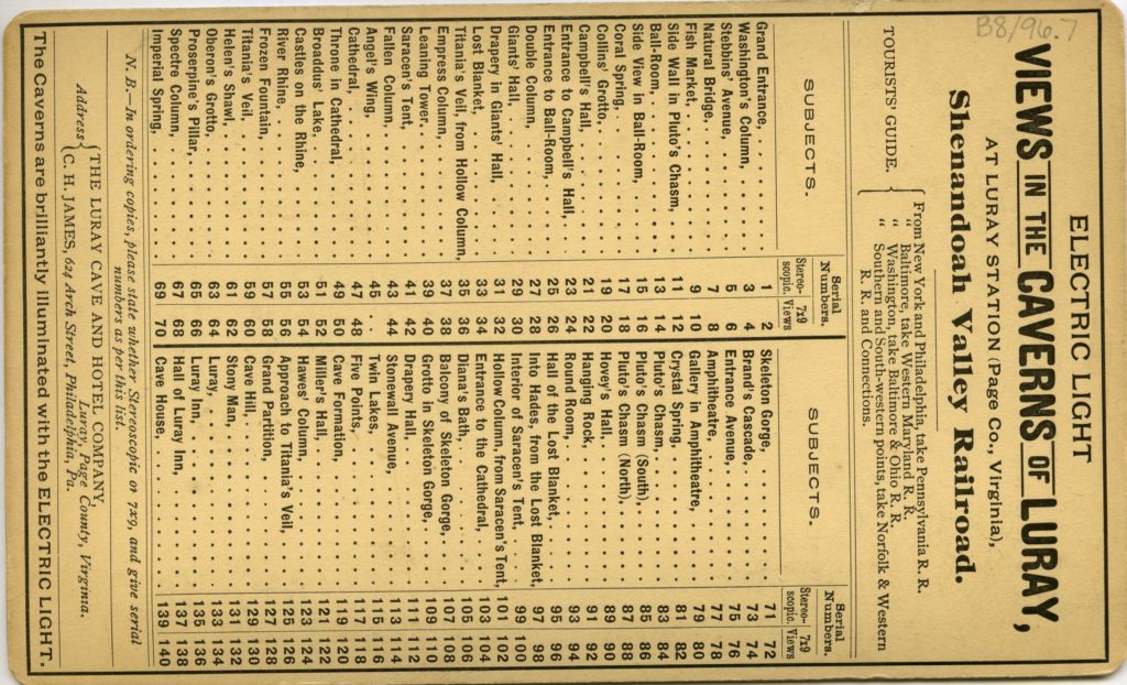
Electric Light Views in the Caverns of Luray,
at Luray Station (Page Co., Virginia),
Shenandoah Valley Railroad.
Tourist’s Guide.:
From New York and Philadelphia, take Pennsylvania R. R.
” Baltimore, take Western Maryland R. R.
” Washington, take Baltimore & Ohio R. R.
” Southern and South-western points, take Norfolk & Western R. R. and Connections.
| Subjects | Serial Numbers | |
| Stereoscopic | 7×9 Views | |
| Grand Entrance | 1 | 2 |
| Washington’s Column | 3 | 4 |
| Stebbins’ Avenue | 5 | 6 |
| Natural Bridge | 7 | 8 |
| Fish Market | 9 | 10 |
| Side Wall in Pluto’s Chasm | 11 | 12 |
| Ball-Room | 13 | 14 |
| Side View in Ball-Room | 15 | 16 |
| Coral Spring | 17 | 18 |
| Collins’ Grotto | 19 | 20 |
| Campbell’s Hall | 21 | 22 |
| Entrance to Campbell’s Hall | 23 | 24 |
| Entrance to Ball-Room | 25 | 26 |
| Double Column | 27 | 28 |
| Giants’ Hall | 29 | 30 |
| Drapery in Giants’ Hall | 31 | 32 |
| Lost Blanket | 33 | 34 |
| Titania’s Veil, from Hollow Column | 35 | 36 |
| Empress Column | 37 | 38 |
| Leaning Tower | 39 | 40 |
| Saracen’s Tent | 41 | 42 |
| Fallen Column | 43 | 44 |
| Angel’s Wing | 45 | . . |
| Cathedral | 47 | 48 |
| Throne in Cathedral | 49 | 50 |
| Broaddus’ Lake | 51 | 52 |
| Castles on the Rhine | 53 | 54 |
| River Rhine | 55 | 56 |
| Frozen Fountain | 57 | 58 |
| Titania’s Veil | 59 | 60 |
| Helen’s Shawl | 61 | 62 |
| Oberon’s Grotto | 63 | 64 |
| Proserpine’s Pillar | 65 | 66 |
| Spectre Column | 67 | 68 |
| Imperial Spring | 69 | 70 |
| Subjects | Serial Numbers | |
| Stereoscopic | 7×9 Views | |
| Skeleton Gorge | 71 | 72 |
| Brand’s Cascade | 73 | 74 |
| Entrance Avenue | 75 | 76 |
| Amphitheatre | 77 | 78 |
| Gallery in Amphitheatre | 79 | 80 |
| Crystal Spring | 81 | 82 |
| Pluto’s Chasm | 83 | 84 |
| Pluto’s Chasm (South) | 85 | 86 |
| Pluto’s Chasm (North) | 87 | 88 |
| Hovey’s Hall | 89 | 90 |
| Hanging Rock | 91 | 92 |
| Round Room | 93 | 94 |
| Hall of the Lost Blanket | 95 | 96 |
| Into Hades, from the Lost Blanket | 97 | 98 |
| Interior of Saracen’s Tent | 99 | 100 |
| Hollow Column, from Saracen’s Tent | 101 | 102 |
| Entrance to the Cathedral | 103 | 104 |
| Diana’s Bath | 105 | 106 |
| Balcony of Skeleton Gorge | 107 | 108 |
| Grotto in Skeleton Gorge | 109 | 100 |
| Drapery Hall | 111 | 112 |
| Stonewall Avenue | 113 | 114 |
| Twin Lakes | 115 | 11 . |
| Five Points | 117 | 118 |
| Cave Formation | 119 | 120 |
| Miller’s Hall | 121 | 122 |
| Hawes’ Column | 123 | 124 |
| Approach to Titania’s Veil | 125 | 126 |
| Grand Partition | 127 | 128 |
| Cave Hill | 129 | 130 |
| Stony Man | 131 | 132 |
| Luray | 133 | 134 |
| Luray Inn | 135 | 136 |
| Hall of Luray Inn | 137 | 138 |
| Cave House | 139 | 140 |
N. B.—In ordering copies, please state whether Stereoscopic or 7×9, and give serial numbers as per this list.
Address:
The Luray Cave and Hotel Company, Luray, Page County, Virginia.
C. H. James, 624 Arch Street, Philadelphia, Pa.
The Caverns are brilliantly illuminated with the Electric Light.
99.11

4261
Two Eyes Are Better Than One
Many people are likely to shut one eye and hastily declare that they get about as good an idea of distance or depth as when both eyes are open. There is a fundamental difference, however, as they will soon find out if they make the following experiment: Hold a pencil, point upward, about an arm’s length before you. Close one eye and with the other hand hold another pencil, point downward, the same distance forward. Lower the upper pencil and try to bring the two points together. With both eyes open it is easy to accomplish; with one eye closed, it is accomplished only by chance. Generally the points are from one to two inches apart.
When the principle of two-eyed vision is used in photography and the results compared with the results of a single lens camera, there are differences equally as great. A stereograph, made with a camera with two lenses or eyes, does not consist of two ordinary pictures mounted on the same card, but of a double picture each side of which is different, reproducing separate views as recorded by the two lenses of the camera, which are placed about three inches apart, so that they photograph two distinct images of the same subject. The combination of these two images by means of the prism lenses of the telebinocular gives exactly the same detail and perspective as would be seen by a person whose two eyes occupied the positions of the two lenses of the camera when the stereograph was taken. Thus, we can secure reproductions that are three-dimentional and life-like in relief as in nature, “truly seeing the place itself.” Two eyes are always better than one.
Copyright by Keystone View Company
113.3

22—(20301)
Weighing and Sorting Raw Silk Skeins, South Manchester, Conn.
Lat. 42° N.; Long. 73° W.
This shows one of the first processes in the manufacture of silk in the United States. This is the room in the factory in which the bales of raw silk are opened. All of our raw silk comes to us from abroad. By far the most of this comes from eastern and southeastern Asia, particularly from the countries of Japan and China.
In these counties the silkworms are grown and do their weaving. The threads of the cocoons which they weave are unwound and spun into tiny threads of yarn. These threads are made up into skeins such as you see in the view. This is known as raw, or reeled silk, as against manufactured silk; that is, silk made up into goods. Before the raw silk leaves Japan, for example, it is carefully weighed and graded. Raw silk absorbs a great deal of moisture, and this must be taken into account in the weighing. The skeins are re-reeled to find the number of broken thread. Naturally, the more broken threads, the less valuable the silk is.
The first thing to be done in the American factory is to check up these weights and gradings. It is this that the woman is doing. On her testing depends the price that the manufacturer pays to the importer.
We import far more silk into this country than is brought into any other. In 1913, the United States used as much raw silk as England, France, Germany, and Italy together. The total consumption amounted to 235,400,000 pounds. To make one of these pounds of raw silk, from 2,500 to 3,000 cocoons have to be used. The thread or filament in each pound is about 6,000 yards long. Separate these threads into single strands, and the strands of one pound of raw silk amounts to almost 1,000 miles.
Copyright by the Keystone View Company.
125.13

3—(13709)
Quarrying Granite, Concord, N. H.
Lat. 43° N.; Long. 72° W.
Granite is quarried, not mined. That is, it is taken out of an open shaft, with no underground shafts leading off from the main opening, as is the case in marble quarries. The view shows a great granite pit,—one of the largest in the United States. The stone is in layers, and is so very hard that it has to be blasted loose. The men in the foreground are busy chiseling those stones, preparatory to splitting them into proper sizes.
The stone is quarried in this manner. A foreman measures out on a layer the shape desired. On the line so laid down holes are drilled and charges of powder are inserted. These charges are set off, hurling a great mass of stone into the bottom of the quarry. The stones are then worked down by drills run by compressed air, and by hand tools such as you see the workman using. The kind of granite you see here is rather easily worked because it splits like wood. Its grain is so straight that steel wedges can be used to block the stone into the desired sizes.
You perhaps have seen buildings partly made of granite. It is used in many of our great monuments, and every graveyard has many tombstones has many tombstones of this material. It is found in many colors,—red, pink, gray, and nearly white. These colors are usually streaked with veins of darker or lighter shades.
The stone is found in more than half of our states. The center of the industry is in New England. Maine, New Hampshire, Massachusetts, Connecticut, New York, Michigan, and California all have important granite quarries. The leading quarries in New Hampshire are at Concord, Milford, North Conway, and Fitzwilliam. At Keene, New Hampshire, is the second largest cutting shed in the United States.
Copyright by The Keystone View Company.
152.66

19198
Learning to Use Gas Masks
The officer before us is instructing his squad in the use of gas masks. Thorough drill in this is of the utmost importance, for a few seconds delay in adjusting his mask in a gas attack may incapacitate a soldier for service and subject him to weeks of agony, if not death.
The Germans were the first to use poison gas in the war, expelling it from metal tubes and trusting to the wind to carry it down upon our allies. This method was soon discarded in favor of gas shells, which they used extensively, sometimes one shell in every three being filled with gas. It became necessary to equip every man in our army with a mask and drill him in the use of it. These masks fit so closely that air cannot enter the nostrils except through the breathing tube. The general principle on which they are constructed is this—that the inhaled air is drawn through certain substances which absorb the gas before it can get into the mask, while the breath which a soldier exhales escapes from the mask through a rubber valve opening only on pressure from the inside. The mask is carried in a canvas case, ready to use on the instant. A soldier, expert in the use of his mask, can put it on in from eight to ten seconds.
Soldiers do not like to wear the mask and will often take great risks rather than be annoyed with them, for even the best of them add somewhat to the difficulty of breathing. Then too, moisture which accumulates inside the mask dims the eye glasses and it becomes difficult to see with them on. Throughout the war there was constant effort to produce a gas against which no mask would be effective. The Germans used phosgene, mustard gas, lachrymal gas and others, but our chemists devised masks effective against each as it appeared.
Copyright by The Keystone View Company